
Current & Past Projects
Current Projects
GLOBAL VOLCANO THERMAL PRECURSORS
Project Goals:
-
The goal of this project was to answer: Are there thermal precursors to eruptions detectable by satellite?
-
For how many volcanoes are there sufficient ASTER data to identify precursors? And within this subset, how many volcanic eruptions can be identified within timely alert levels using thermal measurements?
-
What about those volcanoes for which there are no indicators? Is it due to lack of sufficient data, lack of eruptions with a large enough magnitude, or something more complex?
-
What conclusions can we draw between precursive thermal behaviors and volcanic characteristics, such as tectonic setting, eruption VEI, system type, etc.?
-
Figure Caption: Comparisons of Barren Island volcano, India, with two features visible with ASTER images. Feature A is the main vent, and Feature B is to the SW of the vent. (A) Time series of the max TAB of Feature A for Barren Island volcano with no precursor detected for the 2/16/2013 eruption. (B) Time series of the area (number of VTF pixels) of Feature A for Barren Island volcano, showing a decrease in area before the 2/16/2013 eruption. Refer to Fig. 4 for information on labels in the figures. (C) Time series of the max TAB of Feature B for Barren Island volcano with no precursor detected for the 2/16/2013 eruption. (D) Time series of the area (number of VTF pixels) of Feature B for Barren Island volcano, showing an increase in area before the 2/16/2013 eruption. The increase in area before eruption is shown with a red arrow. (E) Google satellite image of the location of the feature on Barren Island. (F) Visual time series of the TAB images leading up to the 2/16/2013 eruption.

SHISHALDIN VOLCANO (AK, US) PAROXYSMS
Project Goals:
-
The goal of this project was to answer: Are there similarities across paroxysms and eruptions at Shishaldin volcano (US) that can be seen with high temporal resolution GOES satellite data?
-
What are the mechanisms in 2019-2020 and 2023 driving the transition from increasing thermal detections and tremors (RSAM) to ash emissions?
-
What near-surface physical processes are similar between eruptions and what has change? And why?
-
What can high temporal resolution GOES Mesoscale imagery tell us about the transition from elevated thermal activity to onset of ash plume and height?
-
What processes caused the difference between the dominantly effusive 2019-2020 plume and the 2023 plumes that change as the eruption progresses?
-
Can combining several datasets improve co-eruption paroxysm forecasting? And can we determine any precursory behavior for onset of large ash plumes depending on the type of paroxysm?
-

A split window video of GOES Full Disk satellite data of Shishaldin's 9th paroxysm in 2023
SOUTHERN EAST AFRICA RIFT DEFORMATION WITH INSAR
Project Goals:
-
The goal of this project was to answer: Can we identify the tectonic, volcanic, anthropogenic, and seasonal deformations in the southern sections of the East African Rift System with InSAR and GNSS?
-
Where are the active faults in this region?
-
How is deformation distributed and located across the rift?
-
-
Understanding deformation distribution and seismic vs aseismic strain will help:
-
with understanding rifting processes
-
give baseline to future earthquake hazard assessment
-

Participated in the Southern East Africa Rift Workshop in July 2023 in Blantyre, Malawi. This is a group picture of workshop participants! https://southernearsworkshop.org/
PUYEHUE-CORDÓN CAULLE VOLCANO (CHILE) LACCOLITH
Project Goals:
-
The goal of this project was to answer: Is the laccolith on Puyehue-Cordón Caulle volcano (Chile) still active and can this pose an immediate hazard to nearby communities?
-
What is the evolution of the laccolith and its observable behavior? Does this imply that it is still active or cooling?
-
How did the laccolith form and what is its current state? And what does this mean for future hazard assessment?
-
Are different areas of the laccolith cooling at different rates?
-
How can combining thermal satellite data, drone data, and field probe data give us a better understanding of the thermal evolution of the laccolith?
-
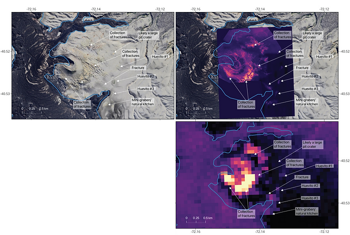
Figure showing the comparison between optical Google Satellite imagery, field collected thermal drone data, and ASTER satellite data of the laccolith. Lava flow is outlined in blue.
Past Projects
SOLID STATE GAS SPECTROSCOPY
Project Goals:
-
The goal of this project was to answer: Can we make a small/mobile system to non-invasively detect biomarkers in a person's breath?
-
What gases can we use to detect biomarkers given our wavelength range?
-
What is the necessary experimental set-up?
-
What non-medical things can also affect gas levels in a person's breath (for example, exercise before sampling, drinking certain beverages before sampling, etc.)
-
Project Publication:

FTIR experimental set-up to understand the wavelength range of the various QCLs
-
Published in SPIE conference proceedings
-
Gave oral presentation of findings at SPIE Photonics Conference 2020
-
Won "best student paper" award at the conference
-
Publication (and conference presentation) can be found for free:
DEFECT DENSITY DETECTOR
Project Goals:
-
The goal of the program was to find a solution to quantitively analyze and compare the amount of defects on a sample morphology image
-
This program was created on MATLAB and the video below gives a brief demonstration of the programs' functionality
This is a video of the Defect Density Detector code in action. I originally coded this as a MatLab program which I converted into an independent interface program.
General Lab Skills:
-
I worked under Professor Manijeh Razeghi and Professor Steven Boyd Slivken to learn about Quantum Cascade Laser theory, growth on the Gas Source Molecular Beam Epitaxy (GSMBE), characterization, and processing
-
Specific machine trainings beyond the GSMBE include:
-
HR-XRD (X-ray Diffraction)
-
SEM (Scanning Electron Microscope)
-
Photoluminescence test (PL)
-
and their corresponding software in order to characterize grown structures
-
-
VOLUMES OF IGNEOUS INTRUSIONS ON FAILED RIFTS
Project Goals:
-
The goal of my section of the project was to understand: What are the size distribution of igneous intrusions on failed rifts?
-
For how many failed rifts do we have length, area, and volume data?
-
What is the range of size variation in these different igneous intrusions?
-
How does this compare to the size variation in successful rifts?
-
-
I was mentored by Molly Gallahue in Seth Stein's lab
